Since this page is automatically translated by the machine, it may be less accurate than human being's work.
Korea Railroad Corporation_Station location information
This data provides location information for mainline railway stations operated by the Korea Railroad Corporation (KORAIL), including key information such as latitude and longitude and the number of entrances and exits for each station. It also includes information on the regional headquarters to which each station belongs, providing accurate geographical information and facility status for stations within the national mainline railway network. The data consists of 202 items and is available in various formats, including CSV, XML, and JSON. This data provides various insights, including the spatial distribution of major railway stations nationwide, accessibility (number of entrances and exits), and jurisdiction status by regional headquarters. For example, it can be used to understand station density in the metropolitan and non-metropolitan areas, accessibility to railway services in specific regions, and the size and convenience of stations based on the number of entrances and exits per station. Station location (latitude and longitude) information can be utilized for in-depth spatial data applications, such as map visualization, GIS analysis, and analysis of transportation connectivity around stations. This data can be utilized as reference material in various fields, including transportation policy formulation, station area development and regional infrastructure planning, public transportation service design, GIS-based research, regional rail service accessibility assessments, tourist information system development, emergency response system design (e.g., 119, 112), and location strategies for private and public institutions. Furthermore, it is useful for various groups, including citizens, travel agencies, and researchers, to develop customized travel plans and service strategies by utilizing the location information and number of entrances at each station.
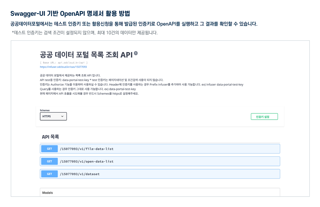
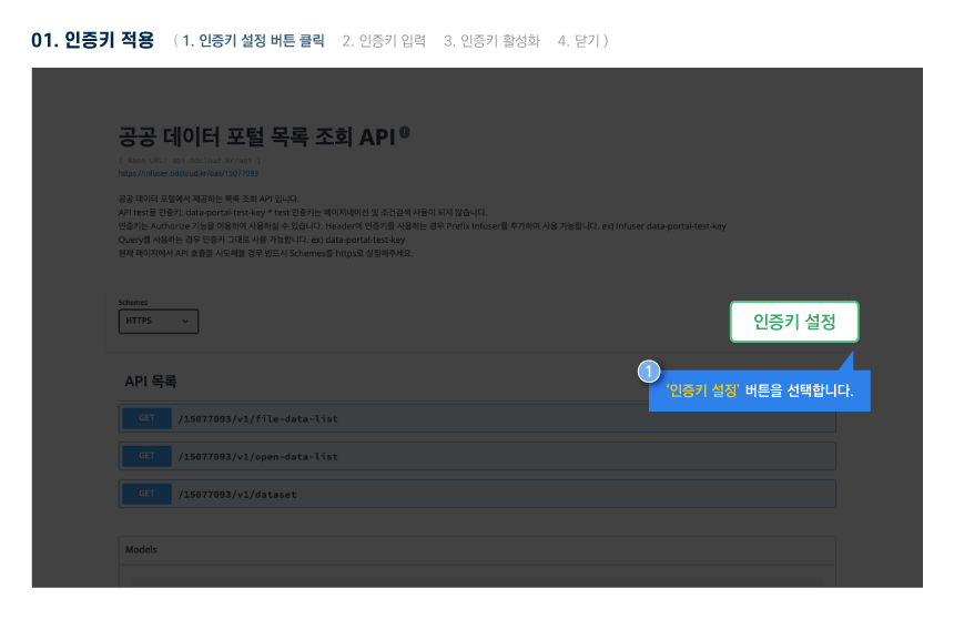
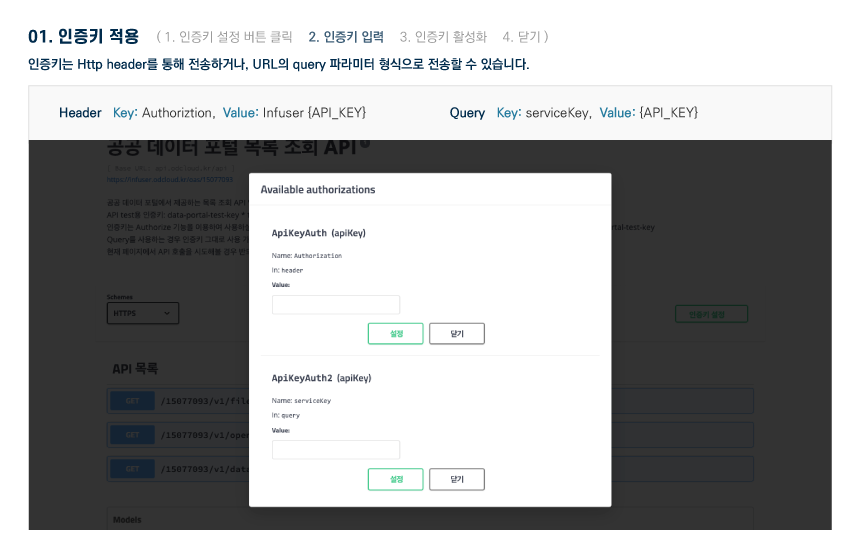
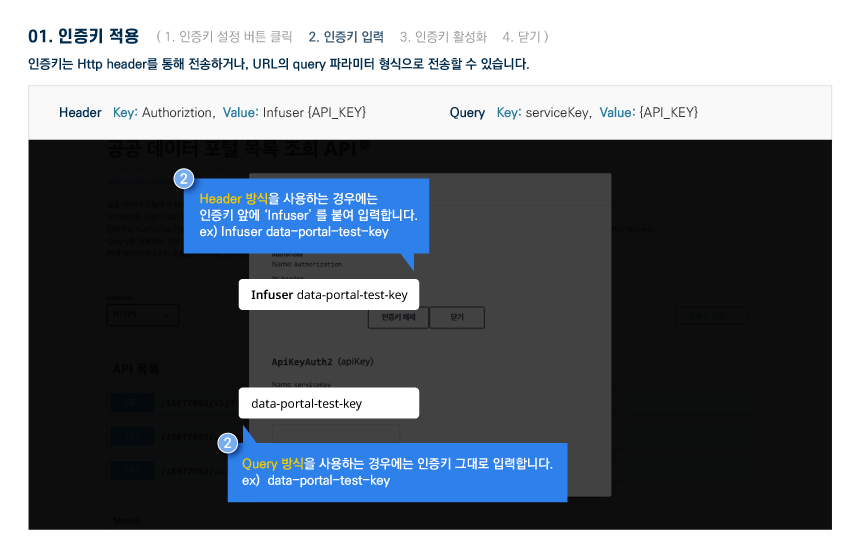
The Public Data Utilization Support Center automatically converts and provides open-format file data of three or more steps open to public data portals into open APIs (RestAPI-based JSON/XML).
To use the open API, you need to sign up for a public data portal membership and apply for utilization. For inquiries about utilization, please contact the Public Data Utilization Support Center.
File data can be used by downloading without logging in.
To use the open API, you need to sign up for a public data portal membership and apply for utilization. For inquiries about utilization, please contact the Public Data Utilization Support Center.
File data can be used by downloading without logging in.
Korea Railroad Corporation_Station location information
File data information Download metadata Provides schema.org based metadata.
The Public Data Utilization Support Center automatically converts and provides open-format file data of three or more steps open to public data portals into open APIs (RestAPI-based JSON/XML).
To use the open API, you need to sign up for a public data portal membership and apply for utilization. For inquiries about utilization, please contact the Public Data Utilization Support Center.
File data can be used by downloading without logging in.
To use the open API, you need to sign up for a public data portal membership and apply for utilization. For inquiries about utilization, please contact the Public Data Utilization Support Center.
File data can be used by downloading without logging in.
Korea Railroad Corporation_Station location information
Open API Information Download metadata Provides schema.org based metadata.
| Service | Korea Railroad Corporation_Station location information_20240401 | ||
|---|---|---|---|
| Classification System | Transportation and logistics - railroad | Provider | |
| Management Agency | Public Data Utilization Support Center | Management agency phone number | 1566-0025 |
| Basis For Retention | Collection Method | ||
| Update Cycle | Occasional (one-time data) | Next Enrollment Date | |
| Media Type | Text | Whole Row | 202 |
| Extension | XML, JSON | Application For Use | 19 |
| Data Limit | Keyword | Railway station location information,Latitude and longitude,Number of entrances,Jurisdiction by regional headquarters,Spatial distribution analysis,Accessibility Assessment,GIS utilization,Development of station areas and public transportation connections | |
| Enrollment | 2024-04-05 | Correction | 2025-09-03 |
| Form Of Provision | Download from open data Portal (the original text file registration) | ||
| Explanation | This data provides location information for mainline railway stations operated by the Korea Railroad Corporation (KORAIL), including key information such as latitude and longitude and the number of entrances and exits for each station. It also includes information on the regional headquarters to which each station belongs, providing accurate geographical information and facility status for stations within the national mainline railway network. The data consists of 202 items and is available in various formats, including CSV, XML, and JSON. This data provides various insights, including the spatial distribution of major railway stations nationwide, accessibility (number of entrances and exits), and jurisdiction status by regional headquarters. For example, it can be used to understand station density in the metropolitan and non-metropolitan areas, accessibility to railway services in specific regions, and the size and convenience of stations based on the number of entrances and exits per station. Station location (latitude and longitude) information can be utilized for in-depth spatial data applications, such as map visualization, GIS analysis, and analysis of transportation connectivity around stations. This data can be utilized as reference material in various fields, including transportation policy formulation, station area development and regional infrastructure planning, public transportation service design, GIS-based research, regional rail service accessibility assessments, tourist information system development, emergency response system design (e.g., 119, 112), and location strategies for private and public institutions. Furthermore, it is useful for various groups, including citizens, travel agencies, and researchers, to develop customized travel plans and service strategies by utilizing the location information and number of entrances at each station. | ||
| Other Notes | |||
| Payment | free | Charge Standard And Unit | Case |
| Scope Of Use | The use permission range limitless | ||
Usage Specification