Since this page is automatically translated by the machine, it may be less accurate than human being's work.
Paju-si, Gyeonggi-do_Building Permit Status
This is public data on the status of building permits in Paju-si, Gyeonggi-do, and consists of building type, permit number, site location, land classification, site area, building area, total floor area, total floor area of expansion, building-to-land ratio, floor area ratio, structure, cancellation type, permit cancellation date, permit date, main use, use area, use zone, total number of parking spaces, and total parking lot area. This dataset can be utilized for identifying the distribution of dangerous buildings in the event of disasters such as earthquakes and fires, establishing safety inspections and emergency response plans, predicting building energy usage and evaluating eco-friendly building certification systems (e.g., green buildings), collecting resident opinions and activating communities, urban regeneration with direct participation of local residents, development of building management apps, urban planning and policy establishment, environmental impact assessment, development of smart cities and GIS-based services, etc.
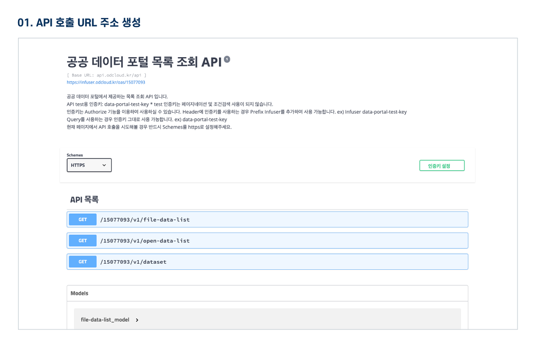
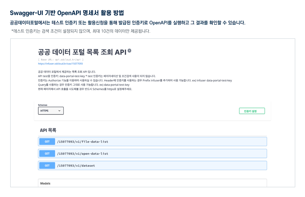
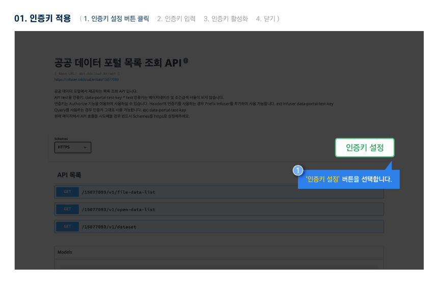
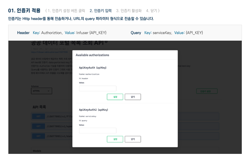
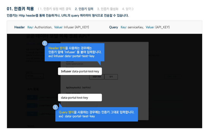
The Public Data Utilization Support Center automatically converts and provides open-format file data of three or more steps open to public data portals into open APIs (RestAPI-based JSON/XML).
To use the open API, you need to sign up for a public data portal membership and apply for utilization. For inquiries about utilization, please contact the Public Data Utilization Support Center.
File data can be used by downloading without logging in.
To use the open API, you need to sign up for a public data portal membership and apply for utilization. For inquiries about utilization, please contact the Public Data Utilization Support Center.
File data can be used by downloading without logging in.
Paju-si, Gyeonggi-do_Building Permit Status
File data information Download metadata Provides schema.org based metadata.
The Public Data Utilization Support Center automatically converts and provides open-format file data of three or more steps open to public data portals into open APIs (RestAPI-based JSON/XML).
To use the open API, you need to sign up for a public data portal membership and apply for utilization. For inquiries about utilization, please contact the Public Data Utilization Support Center.
File data can be used by downloading without logging in.
To use the open API, you need to sign up for a public data portal membership and apply for utilization. For inquiries about utilization, please contact the Public Data Utilization Support Center.
File data can be used by downloading without logging in.
Paju-si, Gyeonggi-do_Building Permit Status
Open API Information Download metadata Provides schema.org based metadata.
| Service | Paju-si, Gyeonggi-do_Building Permit Status_20231012 | ||
|---|---|---|---|
| Classification System | Local development - Region and city | Provider | |
| Management Agency | Public Data Utilization Support Center | Management agency phone number | 1566-0025 |
| Basis For Retention | Collection Method | ||
| Update Cycle | yearly | Next Enrollment Date | 2026-11-17 |
| Media Type | Text | Whole Row | 518 |
| Extension | XML, JSON | Application For Use | 3 |
| Data Limit | Keyword | urban regeneration,eco-friendly architecture,Housing supply status,Building regulations,Building Safety Management,Housing stability,Redevelopment of old housing | |
| Enrollment | 2023-10-13 | Correction | 2025-11-17 |
| Form Of Provision | Download from open data Portal (the original text file registration) | ||
| Explanation | This is public data on the status of building permits in Paju-si, Gyeonggi-do, and consists of building type, permit number, site location, land classification, site area, building area, total floor area, total floor area of expansion, building-to-land ratio, floor area ratio, structure, cancellation type, permit cancellation date, permit date, main use, use area, use zone, total number of parking spaces, and total parking lot area. This dataset can be utilized for identifying the distribution of dangerous buildings in the event of disasters such as earthquakes and fires, establishing safety inspections and emergency response plans, predicting building energy usage and evaluating eco-friendly building certification systems (e.g., green buildings), collecting resident opinions and activating communities, urban regeneration with direct participation of local residents, development of building management apps, urban planning and policy establishment, environmental impact assessment, development of smart cities and GIS-based services, etc. | ||
| Other Notes | Uncollected data blank | ||
| Payment | free | Charge Standard And Unit | Case |
| Scope Of Use | The use permission range limitless | ||
Usage Specification