Since this page is automatically translated by the machine, it may be less accurate than human being's work.
Ministry of Land, Infrastructure and Transport National Geographic Information Institute_api function
This data contains the API specifications for each function of NGTN (OpenAPI), and includes detailed technical information such as the name of each API, function description, input/output parameters, and classification code. It is practical linked development data for building spatial information-based services. 1. Format: CSV 2. Summary of contents ■ func_sn: Unique identification number for each function ■ class_cd: API classification code to which the function belongs ■ func_ctgry_cd: Sub-function category code ■ func_nm: API function name (e.g. XDCameraViewSetColor, SetZoomLevel, etc.) ■ func_dc: Function description (e.g. camera color setting, zoom level adjustment, etc.) ■ input_paramtr_dc: Input parameter description (data type + description) ■ return_paramtr_dc: Return value information (data type + success or return value meaning) ■ plugin_ver: API applied plugin version ■ func_se: Function type (e.g. 2D, 3D, data processing, etc.) ■ indict_at: Display status (Y/N) ■ regist_date, updt_date: First registration date and last modification date 3. Usage examples ■ API call configuration and testing required when public institutions or private developers build map services, disaster information display systems, drone control systems, etc. Utilization for automation ■ When designing UI/UX, use it as a standard for designing menu structures or organizing a functional classification system according to API categories by function, such as map control/data search/3D visualization. ■ When developing a system for automatic documentation of system linkage manuals and API specifications, it can be used to create JSON schemas or documentation forms based on the names, descriptions, and input/output items of each API.
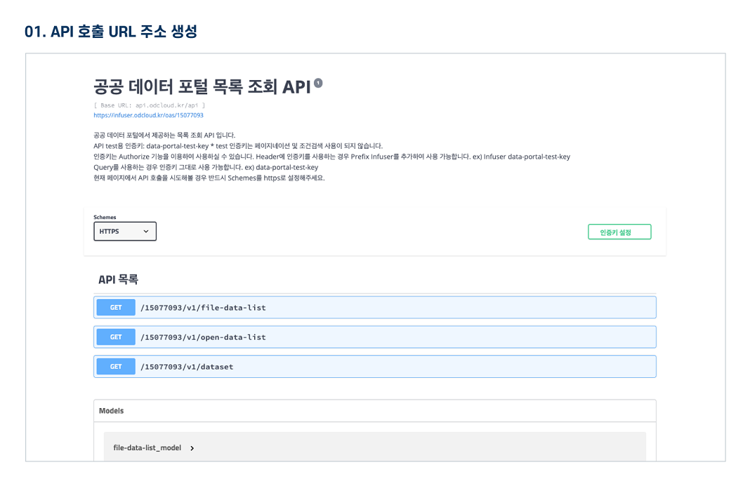
The Public Data Utilization Support Center automatically converts and provides open-format file data of three or more steps open to public data portals into open APIs (RestAPI-based JSON/XML).
To use the open API, you need to sign up for a public data portal membership and apply for utilization. For inquiries about utilization, please contact the Public Data Utilization Support Center.
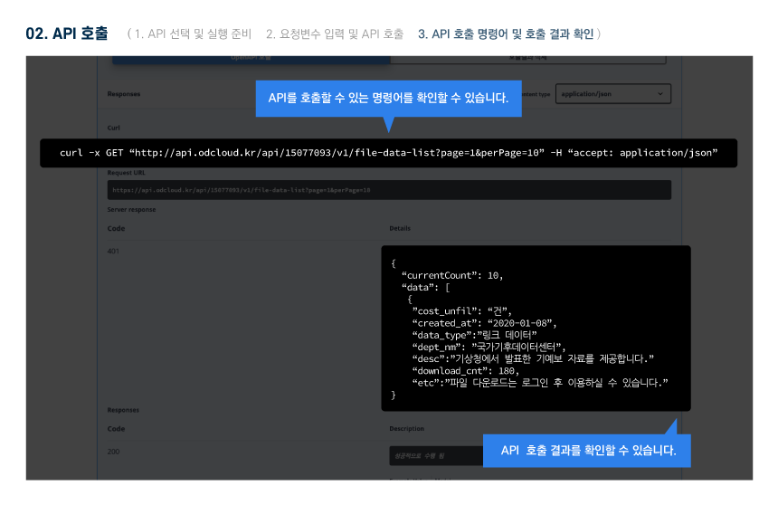
File data can be used by downloading without logging in.
To use the open API, you need to sign up for a public data portal membership and apply for utilization. For inquiries about utilization, please contact the Public Data Utilization Support Center.
File data can be used by downloading without logging in.
Ministry of Land, Infrastructure and Transport National Geographic Information Institute_api function
File data information Download metadata Provides schema.org based metadata.
The Public Data Utilization Support Center automatically converts and provides open-format file data of three or more steps open to public data portals into open APIs (RestAPI-based JSON/XML).
To use the open API, you need to sign up for a public data portal membership and apply for utilization. For inquiries about utilization, please contact the Public Data Utilization Support Center.
File data can be used by downloading without logging in.
To use the open API, you need to sign up for a public data portal membership and apply for utilization. For inquiries about utilization, please contact the Public Data Utilization Support Center.
File data can be used by downloading without logging in.
Ministry of Land, Infrastructure and Transport National Geographic Information Institute_api function
Open API Information Download metadata Provides schema.org based metadata.
| Service | Ministry of Land, Infrastructure and Transport National Geographic Information Institute_api function_20200831 | ||
|---|---|---|---|
| Classification System | General Public Administration - Government resource management | Provider | |
| Management Agency | Public Data Utilization Support Center | Management agency phone number | 1566-0025 |
| Basis For Retention | Collection Method | ||
| Update Cycle | Occasional (one-time data) | Next Enrollment Date | |
| Media Type | Text | Whole Row | 737 |
| Extension | XML, JSON | Application For Use | 3 |
| Data Limit | Keyword | Spatial information,shared use system,OpenAPI,Function Description,guide | |
| Enrollment | 2020-09-25 | Correction | 2025-11-19 |
| Form Of Provision | Download from open data Portal (the original text file registration) | ||
| Explanation | This data contains the API specifications for each function of NGTN (OpenAPI), and includes detailed technical information such as the name of each API, function description, input/output parameters, and classification code. It is practical linked development data for building spatial information-based services. 1. Format: CSV 2. Summary of contents ■ func_sn: Unique identification number for each function ■ class_cd: API classification code to which the function belongs ■ func_ctgry_cd: Sub-function category code ■ func_nm: API function name (e.g. XDCameraViewSetColor, SetZoomLevel, etc.) ■ func_dc: Function description (e.g. camera color setting, zoom level adjustment, etc.) ■ input_paramtr_dc: Input parameter description (data type + description) ■ return_paramtr_dc: Return value information (data type + success or return value meaning) ■ plugin_ver: API applied plugin version ■ func_se: Function type (e.g. 2D, 3D, data processing, etc.) ■ indict_at: Display status (Y/N) ■ regist_date, updt_date: First registration date and last modification date 3. Usage examples ■ API call configuration and testing required when public institutions or private developers build map services, disaster information display systems, drone control systems, etc. Utilization for automation ■ When designing UI/UX, use it as a standard for designing menu structures or organizing a functional classification system according to API categories by function, such as map control/data search/3D visualization. ■ When developing a system for automatic documentation of system linkage manuals and API specifications, it can be used to create JSON schemas or documentation forms based on the names, descriptions, and input/output items of each API. | ||
| Other Notes | |||
| Payment | free | Charge Standard And Unit | Case |
| Scope Of Use | The use permission range limitless | ||
Usage Specification