Since this page is automatically translated by the machine, it may be less accurate than human being's work.
Agriculture, Forestry and Fisheries Food Education and Culture Information Center_Farm Map Information_Chungcheongnam-do
Farmmap, an electronic map of farmland reflecting the field and produced by the Ministry of Agriculture, Food and Rural Affairs and the National Institute of Agricultural Sciences and Technology, is provided in various formats for easy access by users. It includes SHP files and attribute information description materials in CSV format, and these data provide basic information for the efficient operation of agriculture and food-related industries. Through the electronic map of farmland, users can visually check various farmlands in the Chungcheongnam-do region, which can be used as basic data for regional agricultural policies and research. In addition, this data serves as an important tool for analyzing the location and characteristics of farmland, and can be used as useful information for agricultural companies and researchers. ★ Other regional farmmap data nationwide can be viewed by clicking the \More>\ button of \Periodic Past Data\ located at the bottom of this screen. ★ In addition, the format of the reading input date of the CSV file in 2021 has been changed in compliance with the standards of the public data portal. This file is provided in the format of farmmapinformation_CSV_city/province name_city/county/district name_year.csv.
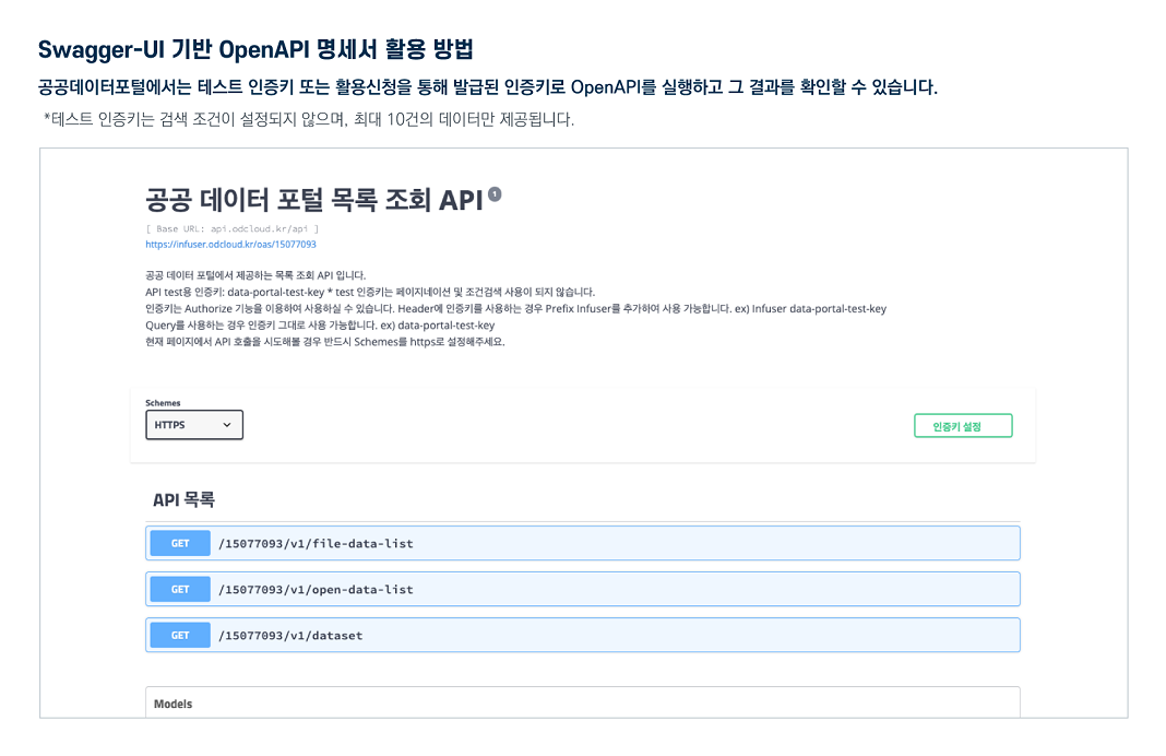
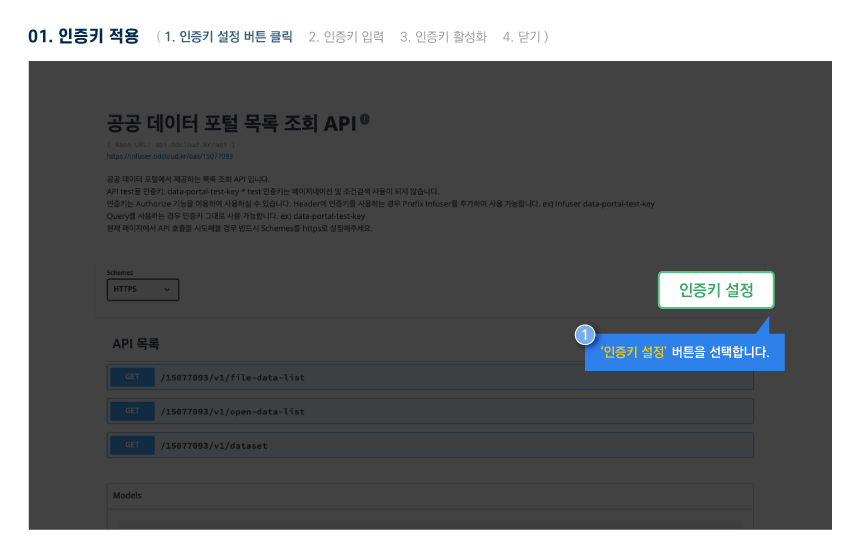
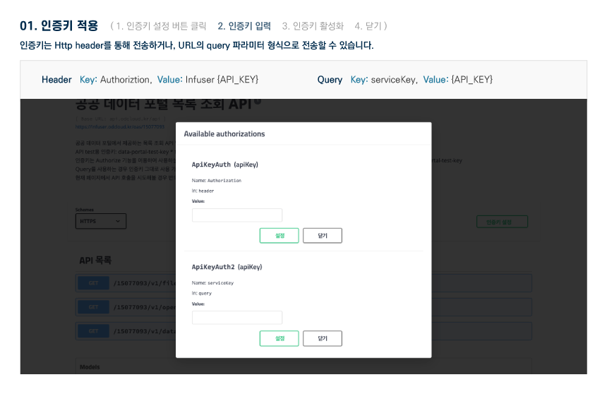
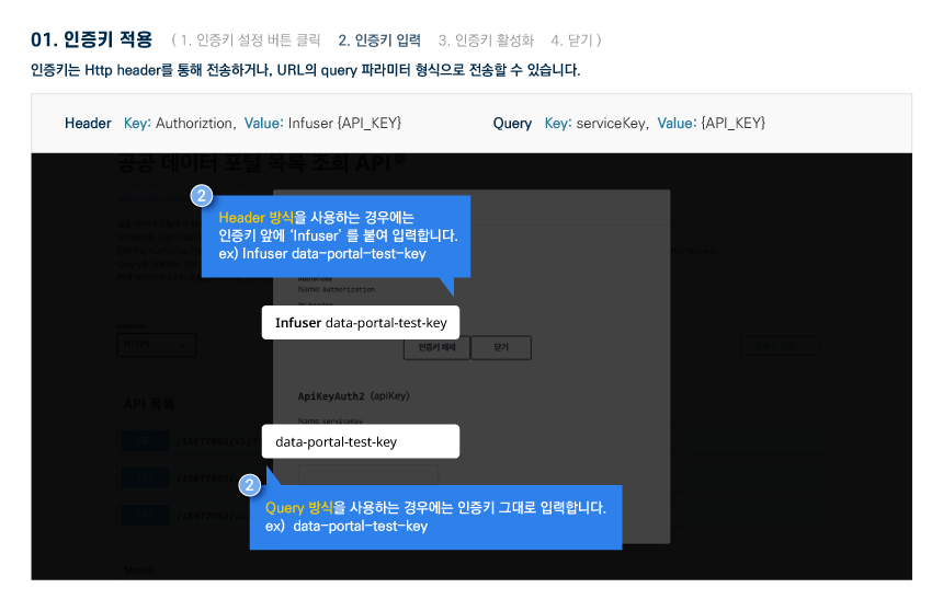
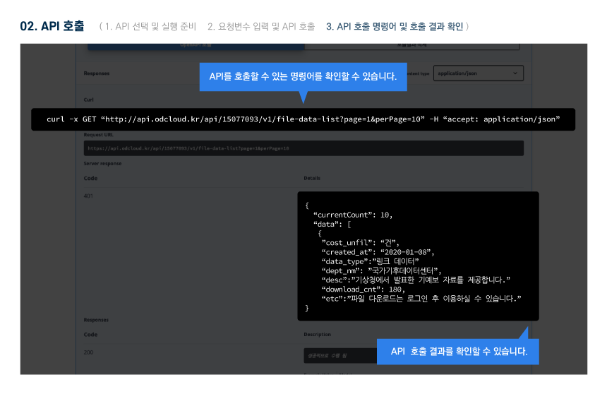
The Public Data Utilization Support Center automatically converts and provides open-format file data of three or more steps open to public data portals into open APIs (RestAPI-based JSON/XML).
To use the open API, you need to sign up for a public data portal membership and apply for utilization. For inquiries about utilization, please contact the Public Data Utilization Support Center.
File data can be used by downloading without logging in.
To use the open API, you need to sign up for a public data portal membership and apply for utilization. For inquiries about utilization, please contact the Public Data Utilization Support Center.
File data can be used by downloading without logging in.
Agriculture, Forestry and Fisheries Food Education and Culture Information Center_Farm Map Information_Chungcheongnam-do
File data information Download metadata Provides schema.org based metadata.
The Public Data Utilization Support Center automatically converts and provides open-format file data of three or more steps open to public data portals into open APIs (RestAPI-based JSON/XML).
To use the open API, you need to sign up for a public data portal membership and apply for utilization. For inquiries about utilization, please contact the Public Data Utilization Support Center.
File data can be used by downloading without logging in.
To use the open API, you need to sign up for a public data portal membership and apply for utilization. For inquiries about utilization, please contact the Public Data Utilization Support Center.
File data can be used by downloading without logging in.
Agriculture, Forestry and Fisheries Food Education and Culture Information Center_Farm Map Information_Chungcheongnam-do
Open API Information Download metadata Provides schema.org based metadata.
| Service | National Institute of Agricultural Sciences and Technology Education and Culture Information_Farm Map Information_Chungcheongnam-do_20211231 | ||
|---|---|---|---|
| Classification System | Agriculture - Forestry, mountain village | Provider | |
| Management Agency | Public Data Utilization Support Center | Management agency phone number | 1566-0025 |
| Basis For Retention | Collection Method | ||
| Update Cycle | Occasional (one-time data) | Next Enrollment Date | |
| Media Type | Text | Whole Row | 1 |
| Extension | XML, JSON | Application For Use | 8 |
| Data Limit | Keyword | Agricultural data,Palm Map,Agricultural land spatial information,Agricultural policy development,Chungcheongnam-do agricultural information,Electronic map service,Geographic Information System | |
| Enrollment | 2022-04-27 | Correction | 2025-07-28 |
| Form Of Provision | Download from open data Portal (the original text file registration) | ||
| Explanation | Farmmap, an electronic map of farmland reflecting the field and produced by the Ministry of Agriculture, Food and Rural Affairs and the National Institute of Agricultural Sciences and Technology, is provided in various formats for easy access by users. It includes SHP files and attribute information description materials in CSV format, and these data provide basic information for the efficient operation of agriculture and food-related industries. Through the electronic map of farmland, users can visually check various farmlands in the Chungcheongnam-do region, which can be used as basic data for regional agricultural policies and research. In addition, this data serves as an important tool for analyzing the location and characteristics of farmland, and can be used as useful information for agricultural companies and researchers. ★ Other regional farmmap data nationwide can be viewed by clicking the \More>\ button of \Periodic Past Data\ located at the bottom of this screen. ★ In addition, the format of the reading input date of the CSV file in 2021 has been changed in compliance with the standards of the public data portal. This file is provided in the format of farmmapinformation_CSV_city/province name_city/county/district name_year.csv. | ||
| Other Notes | For the English item names in the CSV file, please download the Farmmap Attribute Information Definition CSV file from the list and refer to it. For the spatial information data (SHP) file, you must use spatial information software such as QGIS or ArcGIS. | ||
| Payment | free | Charge Standard And Unit | Case |
| Scope Of Use | The use permission range limitless | ||
Usage Specification