Since this page is automatically translated by the machine, it may be less accurate than human being's work.
Ministry of Climate, Energy and Environment, National Institute of Environmental Research_Environmental Impact Assessment Noise and Vibration Information
This service provides information on noise and vibration investigated based on the environmental impact assessment project area and survey point of the National Institute of Environmental Research of the Ministry of Environment, through noise and vibration attribute inquiry, data with spatial information (survey point WFS, survey point WMS), and provides attribute (survey point, survey number, address, vibration (dB(V)), survey number, survey start date, survey end date, noise (dB(A)), Y coordinate, X coordinate, survey point name) and feature information of noise and vibration survey points based on spatial coordinates (spatial coordinate data of the feature, index value constituting spatial data, environmental impact assessment project code, project district division, project point name, method of constructing the corresponding spatial data, validity of the corresponding spatial data value, length for the corresponding space, area for the corresponding space), and provides information through point image inquiry of the noise and vibration survey point based on the corresponding spatial coordinates, such as chart system, return image type, presence or absence of return background image, return image width/height, and size.
※ Application for use is only available on the PC version.
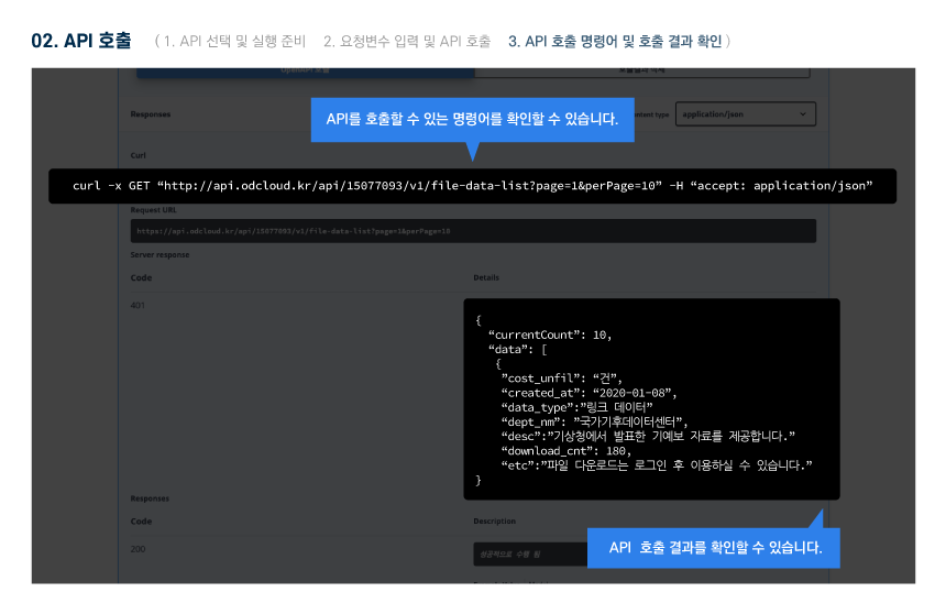
About OpenAPI
Download metadata
Provides schema.org based metadata.
About OpenAPI
Download metadata
Provides schema.org based metadata.
Function
- Application for Use Development level : allowed / Operation level : allowed
- Available traffic 1000000 / Operational account can increase traffic by applying for use case registration
- Requested Link http://apis.data.go.kr/1480523/NoiseVibrationService/getInfoWFS
- Service URL http://apis.data.go.kr/1480523/NoiseVibrationService
Request Parameter
Request Parameter
| Category(Korean) | Category(English) | Size | Division | Sample Data | Description |
|---|---|---|---|---|---|
| ServiceKey | Essential | - | Authentication key received from the public data portal | ||
| srsName | Essential | EPSG:32652 | Coordinate system | ||
| maxFeatures | Optional | 10 | The maximum number of features that WFS should return in response to a request. | ||
| resultType | Optional | results 또는 hits | Defines how WFS will respond to a request. A results value indicates that a complete response containing all requested features should be generated, while a hits value indicates that only a count of features should be returned. | ||
| bbox | Optional | 73297.40248257795,3506059.085416644,803828.180558938,4444265.837193642 | Find features contained within (or partially within) a rectangle of coordinates. The order of the coordinates follows the coordinate system being used. |
Response Element
Response Element
| Category(Korean) | Category(English) | Size | Division | Sample Data | Description |
|---|---|---|---|---|---|
| the_geom | Essential | Spatial coordinate data of the feature | |||
| OBJECTID | Essential | Index value that constitutes the spatial date | |||
| MGTNO | Essential | Environmental Impact Assessment Business Code | |||
| IVSTG_GB | Essential | Business district division | |||
| IVSTG_SPOT | Essential | Business location name | |||
| OPERT_MTH | Optional | How to build the spatial data | |||
| USE_YN | Optional | Whether the spatial data value is valid | |||
| SHAPE_Leng | Optional | Length for that space | |||
| SHAPE_Area | Optional | Area for that space | |||
| RGD_DT | Optional | Registration date | |||
| MODI_DT | Optional | Date of revision | |||
| IVSTG_DT | Optional | Investigation date |
Sample Code
Please check the sample code on your PC.