Since this page is automatically translated by the machine, it may be less accurate than human being's work.
Korea Water Resources Corporation_Status of Hydrological Specifications
ㅁ Overview: Specification information of dams (multipurpose dams, water supply dams) and weirs managed by K-water ㅁ Provided items: Type, height [m], length [m], reservoir area [㎡], designed flood level [EL.m], project completion month (year/month), etc. * Type, height [m], length [m], summit elevation [EL.m], volume [㎥], basin area [㎢], reservoir area [㎡], designed flood level [EL.m], normal full water level [EL.m], flood season restriction water level [EL.m], overflow elevation [EL.m], low water level [EL.m], total reservoir capacity [㎥], effective reservoir capacity [㎥], flood control capacity [㎥] ㅁ Provided locations: 61 locations (21 multipurpose dams, 14 water supply dams, Nakdong River estuary dams, 3 flood control dams, 6 control reservoirs, weirs) 16) Before change: Hydrological resource status (http://opendata.kwater.or.kr/openapi-data/service/pubd/dam/dataPresent/list) After change: Hydrological specifications status (http://apis.data.go.kr/B500001/dam/dataPresent/dataPresentlist) Basic information to be revised in the future
※ Application for use is only available on the PC version.
About OpenAPI
Download metadata
Provides schema.org based metadata.
About OpenAPI
Download metadata
Provides schema.org based metadata.
| Classified | Local development - Water resources | Provided By | |
|---|---|---|---|
| Department | Department No | ||
| API Type | REST | Data Format | JSON+XML |
| Usage | 88 | Keyword | Dam, specifications, multipurpose, water gate resources, dam operation |
| Registered | 2022-02-22 | Edited | 2025-08-21 |
| Payment | free | ||
| Update Cycle | Real-time | Deliberation Type | dev : allow / run : allow |
| Scope of License | |||
| References | 기술문서_한국수자원공사_수문 제원 현황_v1.5-수정.docx | ||
Function
- Application for Use Development level : allowed / Operation level : allowed
- Available traffic 1000000 / Operational account can increase traffic by applying for use case registration
- Requested Link http://apis.data.go.kr/B500001/dam/dataPresent/dataPresentlist
- Service URL http://apis.data.go.kr/B500001/dam/dataPresent
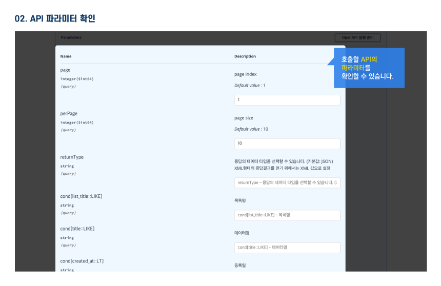
Request Parameter
Request Parameter
| Category(Korean) | Category(English) | Size | Division | Sample Data | Description |
|---|---|---|---|---|---|
| 서비스키 | serviceKey | 100 | Essential | - | Authentication key received from public data portal |
| 댐코드 | damcode | 7 | Optional | 1012110 | Nakdong River Estuary, Juam (Jo), Hoengseong, Juam (Bon), Buan, Gunnam, Gunwi, Daegok, Gampo, Pyeongnim, Gimcheonbu Port, Soyanggang, etc. |
| 출력형식 | _type | 4 | Essential | xml | Choose xml/json |
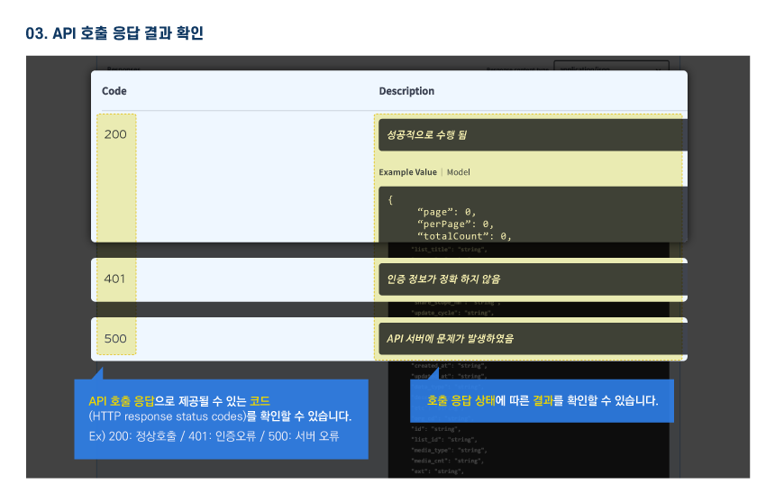
Response Element
Response Element
| Category(Korean) | Category(English) | Size | Division | Sample Data | Description |
|---|---|---|---|---|---|
| 결과코드 | resultCode | 2 | Essential | 00 | result code |
| 결과메시지 | resultMsg | 50 | Essential | NORMAL SERVICE | result message |
| 완료일 | competDe | 10 | Optional | 1973-12-31 | Due date |
| 형식 | damFom | 100 | Optional | E.C.R.D | form |
| 하천 | damdgr | 30 | Essential | 소양강 | River |
| 댐이름 | damnm | 30 | Essential | 소양강 | Dam name |
| 유역면적(㎢) | dgrar | 20 | Optional | 2,703 | Basin area (㎢) |
| 홍수조절용량(백만㎥) | floodadjstCpcty | 20 | Optional | 500 | Flood control capacity (million ㎥) |
| 상시만수위(EL.m) | floodseLmttWal | 20 | Optional | 190.3 | Full-time water level (EL.m) |
| 연간용수공급량(백만㎥) | fyerUswtrsuplyplanqy | 20 | Optional | 1,213 | Annual water supply (million ㎥) |
| 높이(m) | hg | 20 | Optional | 123 | height (m) |
| 저수위(EL.m) | lowlevel | 20 | Optional | 150 | Low water level (EL.m) |
| 길이(m) | lt | 20 | Optional | 530 | Length (m) |
| 정상표고(EL.m) | nrmltAl | 20 | Optional | 203 | Normal elevation (EL.m) |
| 홍수기제한수위(EL.m) | ordtmFwal | 20 | Optional | 193.5 | Flood season limit water level (EL.m) |
| 계획홍수위(EL.m) | planFwal | 20 | Optional | 198 | Planned Flood Level (EL.m) |
| 저수면적(㎢) | rsvwtAr | 20 | Optional | 70 | Low water area (㎢) |
| 사업기간 | strwrkDe | 10 | Optional | 1967-04-01 | business period |
| 총저수용량(백만㎥) | totRsvwtcpcty | 20 | Optional | 2,900 | Total storage capacity (million ㎥) |
| 유효저수용량(백만㎥) | validRsvwtcpcty | 20 | Optional | 1,900 | Effective storage capacity (million ㎥) |
| 체적(천㎥) | vl | 20 | Optional | 9,591 | Volume (thousand ㎥) |
| 월류정표고(EL.m) | wollyupvlAl | 20 | Optional | 185.5 | Overwater Elevation (EL.m) |
Sample Code
Please check the sample code on your PC.