Since this page is automatically translated by the machine, it may be less accurate than human being's work.
Korea Mountaineering and Trekking Support Center_100 Famous Mountains Forest Trail POI Information Service
This data is an open API service registered and provided by the Korea Mountaineering and Trekking Support Center on January 4, 2022, and is a service that allows you to search for point of interest (POI) information on major forest trail sections of the 100 most famous mountains in Korea. Through the API, you can call up information such as point of interest identifier, forest trail identifier, forest trail name, latitude, longitude, elevation above sea level, source place type name, source place type code, place name, description, reference date and time, source survey direction name, landmark destination name, source landmark destination direction name, and source landmark destination code. This can be utilized in various fields such as guidance for each trail section, visualization of major points, identification of safety facility locations, analysis of forest trail use information, and construction of GIS-based path visualization and management system. Information is supported in JSON+XML format.
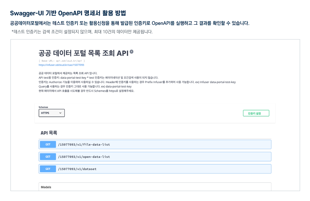
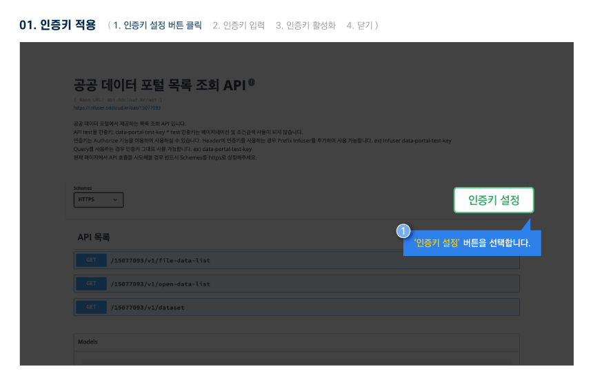
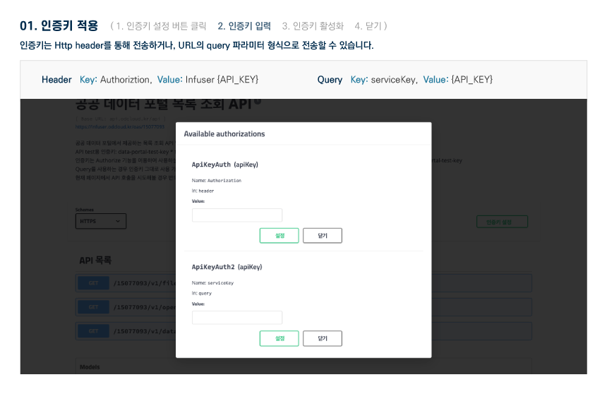
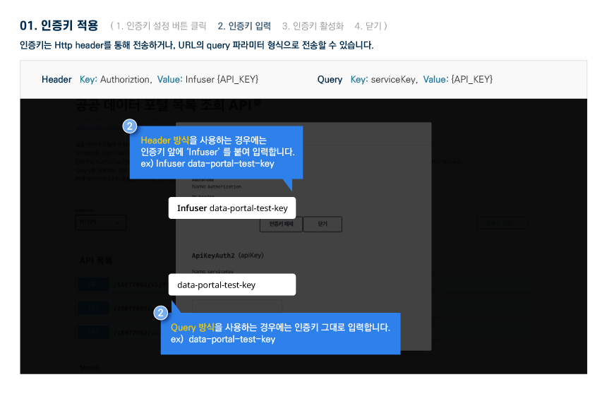
※ Application for use is only available on the PC version.
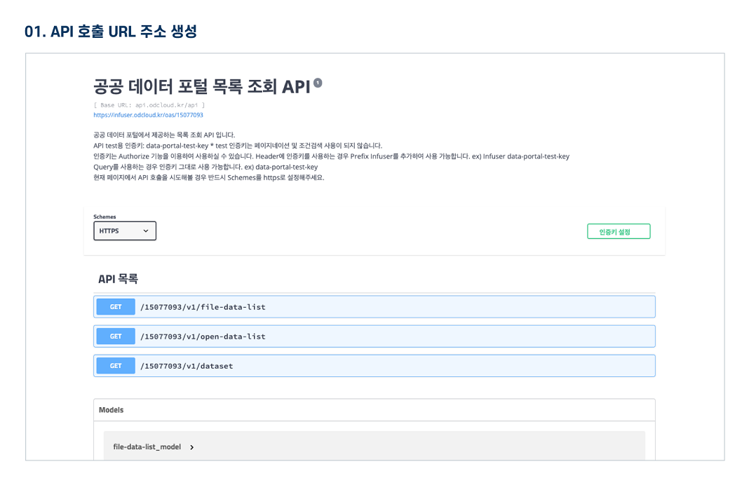
About OpenAPI
Download metadata
Provides schema.org based metadata.
About OpenAPI
Download metadata
Provides schema.org based metadata.
| Classified | Agriculture - Forestry, mountain village | Provided By | |
|---|---|---|---|
| Department | Department No | ||
| API Type | REST | Data Format | JSON+XML |
| Usage | 122 | Keyword | Mountain, forest path, POI, latitude, longitude, elevation |
| Registered | 2022-01-04 | Edited | 2025-11-12 |
| Deliberation Type | dev : allow / run : disallow | ||
| Payment | free | ||
| Scope of License | |||
| References | KMOS-APR-B07_01_02_오픈API 활용자가이드_(100대명산 숲길POI정보 조회 서비스)_V1.4.docx | ||
Function
- Application for Use Development level : allowed / Operation level : Not allowed
- Available traffic 100000 / Operational account can increase traffic by applying for use case registration
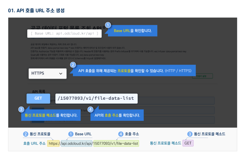
- Requested Link http://apis.data.go.kr/B553662/fmmtnFrtrlPoiInfoService/getFmmtnFrtrlPoiInfoList
- Service URL http://apis.data.go.kr/B553662/fmmtnFrtrlPoiInfoService
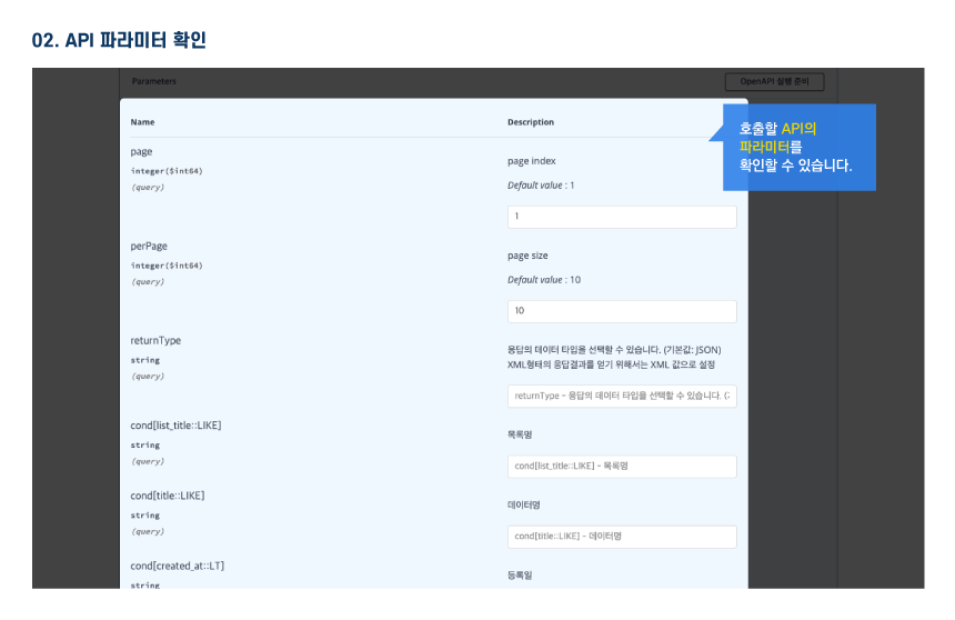
Request Parameter
Request Parameter
| Category(Korean) | Category(English) | Size | Division | Sample Data | Description |
|---|---|---|---|---|---|
| 서비스키 | serviceKey | 100 | Essential | - | Authentication key received from public data portal |
| 페이지 번호 | pageNo | 4 | Optional | 1 | page number |
| 한 페이지 결과 수 | numOfRows | 4 | Optional | 1 | number of results per page |
| 데이터 타입 | type | 4 | Optional | xml | The output method of the response result can be converted and provided in xml and json format |
| 숲길명 | srchFrtrlNm | 100 | Optional | 가리왕산 | The name of the forest path you want to search for “TEXT” |
| 장소유형코드 | srchPlaceTpeCd | 10 | Optional | SIGN | Location Type Code “TEXT” PEAK: Peak SPRING: Fountain SCENERY: Landscape Resources TOILET: Toilet REST: Shelter CAMP: Campsite CULTURAL: Cultural Resources DANGER: Dangerous Area ENTRY: Trail Entrance INFO: Information Center PHOTO: Photo Zone SHELTER: Sh |
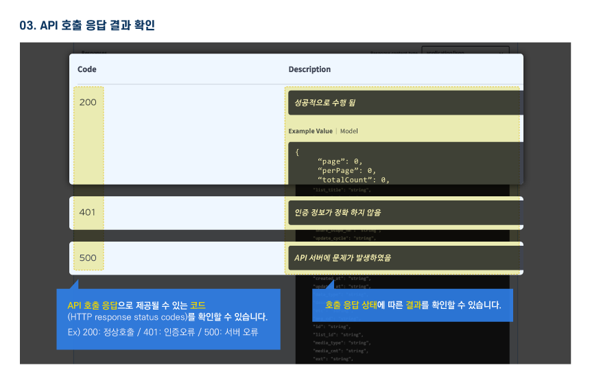
Response Element
Response Element
| Category(Korean) | Category(English) | Size | Division | Sample Data | Description |
|---|---|---|---|---|---|
| 결과코드 | resultCode | 10 | Essential | 0 | result code |
| 결과메시지 | resultMsg | 20 | Essential | NORMAL_SERVICE | result message |
| 한 페이지 결과 수 | numOfRows | 4 | Essential | 1 | number of results per page |
| 페이지 번호 | pageNo | 4 | Essential | 1 | page number |
| 전체 결과 수 | totalCount | 5 | Essential | 28204 | total number of results |
| 관심지점식별자 | poiId | 10 | Essential | 0000000292 | point of interest identifier |
| 숲길식별자 | frtrlId | 10 | Essential | 0000000003 | forest path identifier |
| 위도 | lat | 13 | Essential | 37.461731 | Latitude |
| 경도 | lot | 13 | Essential | 128.535599 | Hardness |
| 해발고도 | aslAltide | 13 | Essential | 1007.32 | elevation |
| 원천장소유형명 | orgnPlaceTpeNm | 10 | Optional | 갈림길 | Source place type name |
| 장소명 | placeNm | 100 | Optional | 갈림길 | place name |
| 설명내용 | dscrtCn | 2000 | Optional | 마항치 사거리 | Description |
| 원천조사진행방향명 | orgnExmnnPrgrsDrcntNm | 20 | Optional | Source investigation direction name | |
| 이정표목적지1명 | sgnpstDstn1Nm | 100 | Optional | 발심사 | 1 milestone destination |
| 원천이정표목적지1방향명 | orgnSgnpstDstn1DrcntNm | 4 | Optional | 유턴 | Source Milestone Destination 1 Direction Name |
| 이정표목적지2명 | sgnpstDstn2Nm | 100 | Optional | 숙암리 | 2 milestone destinations |
| 원천이정표목적지2방향명 | orgnSgnpstDstn2DrcntNm | 4 | Optional | 좌 | Source Milestone Destination 2 Direction Name |
| 이정표목적지3명 | sgnpstDstn3Nm | 100 | Optional | 회동리 | 3 milestone destinations |
| 원천이정표목적지3방향명 | orgnSgnpstDstn3DrcntNm | 4 | Optional | 직진 | source milestone destination 3 directions name |
| 이정표목적지4명 | sgnpstDstn4Nm | 100 | Optional | 휴양림 | 4 milestone destinations |
| 원천이정표목적지4방향명 | orgnSgnpstDstn4DrcntNm | 4 | Optional | 우 | source milestone destination 4 directions name |
| 원천장소유형코드 | orgnPlaceTpeCd | 10 | Optional | SIGN | Source place type code |
| 원전이정표목적지1코드 | orgnSgnpstDstn1DrcntCd | 10 | Optional | UT | Nuclear power plant milestone destination 1 code |
| 원전이정표목적지2코드 | orgnSgnpstDstn2DrcntCd | 10 | Optional | TL | Nuclear power plant milestone destination 2 code |
| 원전이정표목적지3코드 | orgnSgnpstDstn3DrcntCd | 10 | Optional | ST | Nuclear power plant milestone destination 3 code |
| 원전이정표목적지4코드 | orgnSgnpstDstn4DrcntCd | 10 | Optional | TR | Nuclear power plant milestone destination 4 code |
| 기준일시 | crtrDt | 20 | Essential | 2022-10-26 02:14:09 | Base date and time |
| 숲길명 | frtrlNm | 100 | Optional | 가리왕산 | forest road name |
Sample Code
Please check the sample code on your PC.